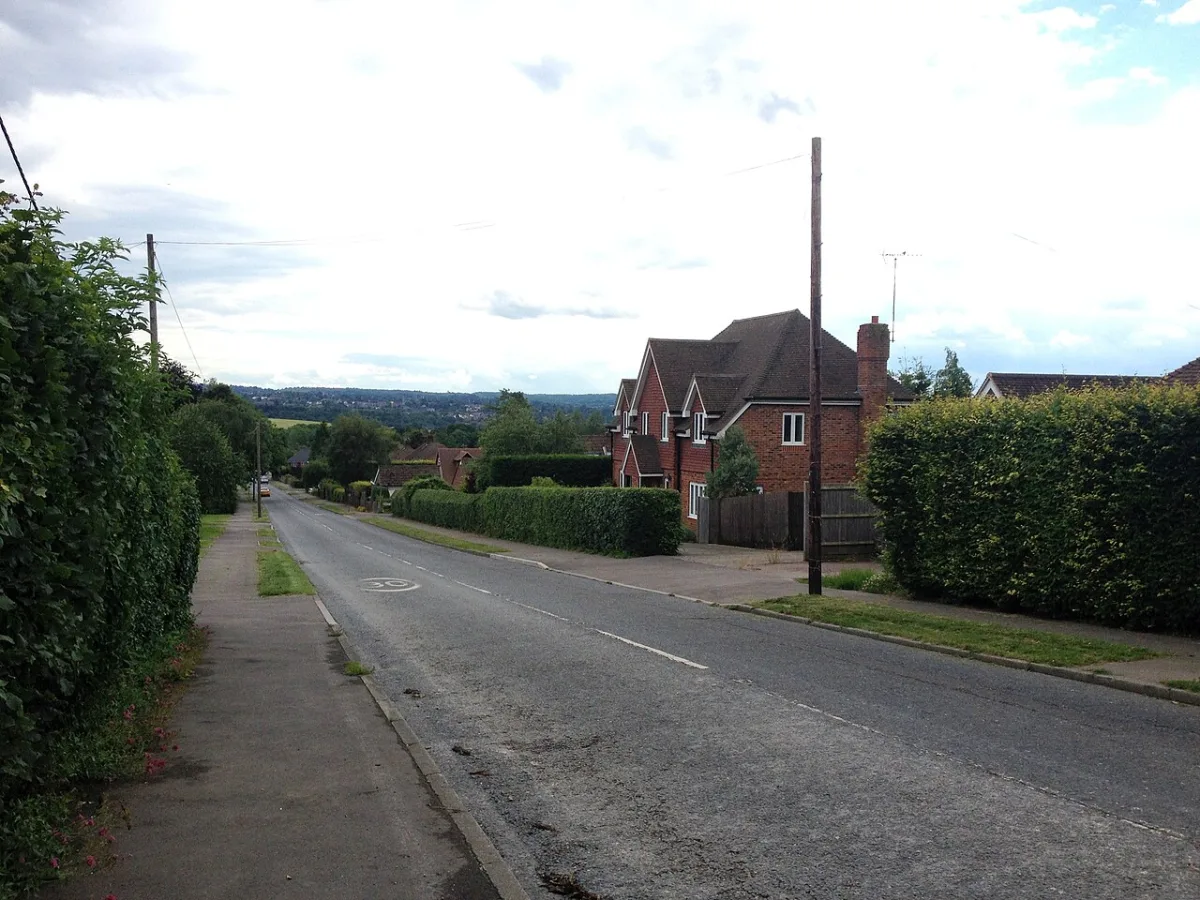

Permission in principle for up to seven homes on Green Belt land behind Childsbridge House, Kemsing, was granted on 4 September, with no conditions attached.
The committee met on Thursday 3 September and granted the application. The decision notice was issued the next day, Friday 4 September, with no conditions and a single informative about what the follow-up technical details application should contain. The three other planning applications on the agenda were granted the same day. The committee's printed minutes, published on 14 September, confirm the final outstanding item: the tree preservation order on five oaks at Four Elms Road, Edenbridge, was confirmed without amendment. This report, first published on 25 August, sets out the case officers, the highway authority and the parish council put before the meeting, and now carries what each item was given.
Plans for up to seven homes on Green Belt land behind Childsbridge House, Kemsing, went before Sevenoaks District Council’s planning committee on Thursday 3 September and were granted. The applicant is the village’s own district councillor. Planning officers had recommended approval; Kemsing Parish Council objected. The council’s register records the decision as issued on Friday 4 September. (Sevenoaks District Council, Public Access, 26/01327/PIP, summary)
The application, reference 26/01327/PIP, is for “permission in principle” for between one and seven dwellings on a 0.36 hectare plot west of Childsbridge Lane, between the M26 and the houses to the south. It was referred to the Development Management Committee “as the applicant is a Sevenoaks District Councillor”. (Sevenoaks District Council, officer report, item 4.4)
The council’s planning register names the applicant as Mr Chris Haslam. (Sevenoaks District Council, Public Access, 26/01327/PIP, further information) Councillor Chris Haslam represents Kemsing ward for the West Kent Independent Group. (Sevenoaks District Council, Your Councillors) He is not one of the 19 members of the committee that will decide it. (Sevenoaks District Council, Development Management Committee membership)
The meeting was held at 7pm in the Council Chamber at Argyle Road. The grant of permission in principle was published on the planning portal on 4 September. (Sevenoaks District Council, agenda for 3 September 2026; Public Access, 26/01327/PIP, documents)
What is being asked for
Permission in principle is a two-stage route. This first stage settles only whether housing is acceptable on the site at all, and how much. Layout, design, access and parking come later, in a “technical details” application. Officers cannot attach conditions at this stage, and the report recommends none. (Officer report, item 4.4)
The report describes the site as:
- a rectangular plot behind existing houses, with the M26 to the north
- wholly within the Metropolitan Green Belt
- covered by a Tree Preservation Order along its eastern edge, with a telecoms mast in the north-east corner
- crossed east to west by a high-pressure gas pipeline
- half in residential use and half in agricultural use
The southern half was confirmed as residential garden in 2021, under certificate 21/01101/LDCEX. The northern half is treated as farmland, after a 2020 notice for a hay barn described the land as used for hay and grazing. (Officer report, item 4.4)
The application was received on 26 May and validated on 2 June. (Public Access, 26/01327/PIP, summary)
Why officers say it is “grey belt”
The case turns on the revised National Planning Policy Framework, which the report dates to August 2026. Building homes in the Green Belt is normally “inappropriate”, but the Framework now allows it on “grey belt” land where four tests are met. Officers conclude the site passes all of them. (Officer report, item 4.4)
Their reasoning, in short:
- Kemsing is not a “large built-up area”, so the site does not check urban sprawl
- the site is not a gap between towns, because houses already occupy its southern half
- Kemsing was not treated as a historic town in the council’s own Green Belt assessment
- the district “cannot meet its 5-year housing land supply targets and does not have an up-to-date local plan”, so there is an unmet need for housing
- Kemsing library is a 14-minute walk away and Seal high street a 20-minute walk, with a footpath opposite the site and a bus stop a short distance along the lane
Officers are candid about the transport picture. The government’s Connectivity Tool scores the site 45 out of 100, which the report calls “low”, with low scores for every form of public transport. They still conclude it is sustainably located, “taking into account the site context and the ‘on the ground’ situation”. (Officer report, item 4.4)
Because the site is found to be grey belt, the report says there is “no requirement to address further the impact of development on the Green Belt’s openness”.
The parish council’s objection
Kemsing Parish Council has objected. Its response, quoted in the report, raises three points. (Officer report, item 4.4)
First, it asks whether the land is still agricultural. It recalls the 2020 barn application, when “the applicant confirmed at the time that the land was used for hay production and grazing”, and asks the district council to confirm the land use.
Second, it points to a 2009 refusal on the site. An application to demolish existing dwellings and build two replacements was turned down as inappropriate development “harmful to the maintenance and character of the Green Belt and its openness”. The parish council says one to seven homes “will have a detrimental effect on the openness of the Green Belt”.
Third, it challenges the applicant’s supporting document, which cited a 27-home scheme at The Laurels, Kemsing, as a benchmark. “This planning application was refused by Sevenoaks District Council, and we fail to see the relevance of this application here,” the parish council says. It also notes that Palace Park Wood and Oxenhill Shaw, listed in that document as Kemsing facilities, are not in Kemsing.
No members of the public commented. The report records “None received” under representations. (Officer report, item 4.4)
Highways and the gas main
Kent County Council Highways raised no objection in principle, but described the location as “largely unsustainable at present”. The site is 1.1 to 1.2km from Kemsing village, a 12 to 15 minute walk on a continuous footway. Bus route 6 runs “approximately 9-10 times per weekday at broadly hourly intervals”, and Sevenoaks station is about 5.5km away. KCC expects “the vast majority of trips will be undertaken by private car”. (Officer report, item 4.4)
SGN, which runs the high-pressure gas pipeline through the middle of the site, objected at first. It later withdrew, while telling officers it “had reservations over the capacity of the site to accommodate 7 dwellings”. Officers say the withdrawal was confirmed on the basis of the full one-to-seven range.
Seven homes on 0.36 hectares would be 19 dwellings per hectare, below the 30 the council’s Core Strategy expects. One home would be two per hectare. The report says that with 93% of the district in the Green Belt, “ensuring that densities are maximised is of great importance”, and expects the number to be settled at the technical details stage. (Officer report, item 4.4)
Also decided that evening
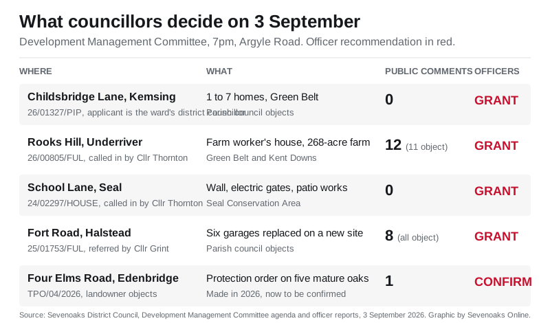
Four other items were listed for the same meeting. The three planning applications among them were all granted, with decision notices issued on Friday 4 September. The fifth item, a tree preservation order, was confirmed at the meeting. The committee’s printed minutes record that the tree preservation order and the Seal and Underriver applications drew no public speakers and no member reserved them for debate, so all three went through en bloc without debate under the council’s constitution. Only the Fort Road and Childsbridge Lane items were debated. (Sevenoaks District Council, agenda for 3 September 2026; printed minutes, 3 September 2026)
A farm worker’s house at Underriver. Application 26/00805/FUL is for an agricultural worker’s dwelling with solar panels on land south-east of Broadhoath Wood, Rooks Hill. It was called in by Councillor Julia Thornton on four grounds, including the impact on the Green Belt and the Kent Downs National Landscape and “questions over the legitimacy of agricultural tenancy of the building”. The applicant’s case is that White Rock Farm covers 109 hectares (268 acres) and has been farmed by the family for over 60 years. The holding breeds rare-breed livestock, runs a riding school and provides land-based education. Twelve comments were received, 11 of them objecting. Officers recommended approval with a condition tying the house to an agricultural worker. Granted on 4 September. Before the meeting Councillor Thornton, who had called the item in, told officers that having read the papers she considered the application policy compliant and that it should be granted, and Seal Parish Council confirmed it had no objection in principle, asking for conditions on occupancy and lighting that the report already contained. (Officer report, item 4.1; Late observation sheet, 3 September 2026; Public Access, 26/00805/FUL)
Gates and a wall in Seal Conservation Area. Application 24/02297/HOUSE at Lulworth, School Lane, Seal, covers a front retaining wall, wooden electric gates, a raised rear patio and outbuilding works. Councillor Thornton called it in over the conservation area and the setting of neighbouring listed buildings. Seal Parish Council asked for precise details of a gate it measured from the drawings at 200cm high. No neighbours wrote in. Officers recommended approval, with stone and mortar samples to be agreed first. Granted on 4 September, with that condition rewritten after the parish council said the 2m gate would be out of keeping with the village. It now requires a specification and design proposals for the gate as well as the stone and mortar samples, and bars any lighting on the wall or gate until details are approved. An informative was added saying the gate must be visually permeable and in keeping with the Seal Conservation Area. (Officer report, item 4.2; Late observation sheet, 3 September 2026; Public Access, 24/02297/HOUSE)
Six garages at Fort Road, Halstead. Application 25/01753/FUL would demolish six garages in woodland north of 4 to 7 Fort Road and build six replacements on land west of number 41, with new hardstanding. Councillor John Grint referred it over the Green Belt. Halstead Parish Council objects and fears the scheme “is a stepping stone to full application for housing”, asking for a covenant against it. All eight public comments object. Officers recommended approval, with a 10% biodiversity net gain plan before any work starts. Granted on 4 September, after officers widened another condition: the outbuildings marked for demolition, any hard surfacing around them and all the demolished material must now be off the site before work begins on the replacement garages, to protect Green Belt openness and the ancient woodland buffer. (Officer report, item 4.3; Late observation sheet, 3 September 2026; Public Access, 25/01753/FUL)
Five oaks at Edenbridge. Tree Preservation Order 04/2026 protects a group of five mature oaks in front of a house on Four Elms Road. The landowner has objected, arguing the council has not shown the trees were under threat or evidenced their amenity value. Officers recommended the order is confirmed without amendment, and did not shift after a tree consultancy acting for the objector argued that two declining oaks in the group, labelled G1a and G1d, should be excluded. The council’s answer was that a group order protects a cohesive landscape feature rather than five individually qualifying trees, and that the consultancy’s own “poor” ratings sat oddly with earlier submissions that treated the same trees as suitable for retention and management. Confirmed without amendment. The committee’s printed minutes, published on 14 September, resolve “That TPO. 4 of 2026 be confirmed without amendment”, so the order protecting the group of five mature oaks now stands as made. (Officer report, item 5.1; Late observation sheet, 3 September 2026; Printed minutes, 3 September 2026)
What it means for residents
The Childsbridge Lane site now has permission in principle for housing. Nothing can be built until a technical details application is approved, and that is when the number of homes, their design, the access onto Childsbridge Lane and parking will be judged. The decision notice attaches no conditions, only an informative recommending that everything asked for in the officer’s report and the consultee replies is submitted with that second application. The report says the development will be liable for the Community Infrastructure Levy at that stage. (Officer report, item 4.4)
There is no further consultation stage on this permission. The next chance for neighbours to comment is on the technical details application, when it is submitted and validated.
The full file, including the applicant’s planning statement and the consultee replies, is on the council’s planning portal under 26/01327/PIP. For how to search, track and comment on any application in the district, see our page on Sevenoaks planning applications.
Sources
- Sevenoaks District Council, Development Management Committee agenda, 3 September 2026
- Officer report, item 4.4, 26/01327/PIP, Land at the rear of Childsbridge House
- Public Access, 26/01327/PIP, summary, further information and documents, including the grant of permission in principle dated 4 September 2026
- Late observation sheet, Development Management Committee, 3 September 2026
- Sevenoaks District Council, Your Councillors and Development Management Committee membership
- Officer report, item 4.1, 26/00805/FUL, Rooks Hill, Underriver
- Officer report, item 4.2, 24/02297/HOUSE, School Lane, Seal
- Officer report, item 4.3, 25/01753/FUL, Fort Road, Halstead
- Officer report, item 5.1, TPO/04/2026, Four Elms Road, Edenbridge
- Development Management Committee, printed minutes, 3 September 2026 (published 14 September 2026: the TPO confirmed without amendment, the en bloc treatment of the unreserved items, and the debates on the Fort Road and Childsbridge Lane applications)
Image: Childsbridge Lane, Kemsing, by Chris Whippet, CC BY-SA 2.0, via Geograph, file. Agenda graphic by Sevenoaks Online.
Have your say